 Click on image to enlarge. | Terrace ViewRelease Date: March 19, 2013 Topics: Hollows, Larrocha, Smooth Terrain, Tectonics |
Date acquired: February 13, 2013
Image Mission Elapsed Time (MET): 3038847
Image ID: 3509826
Instrument: Narrow Angle Camera (NAC) of the Mercury Dual Imaging System (MDIS)
Center Latitude: 42.20°
Center Longitude: 292.10° E
Resolution: 22 meters/pixel
Scale: The field of view in this image is approximately 20 km (12 mi.) across
Incidence Angle: 73.6°
Emission Angle: 9.8°
Phase Angle: 63.8°
(North is down in this image.)
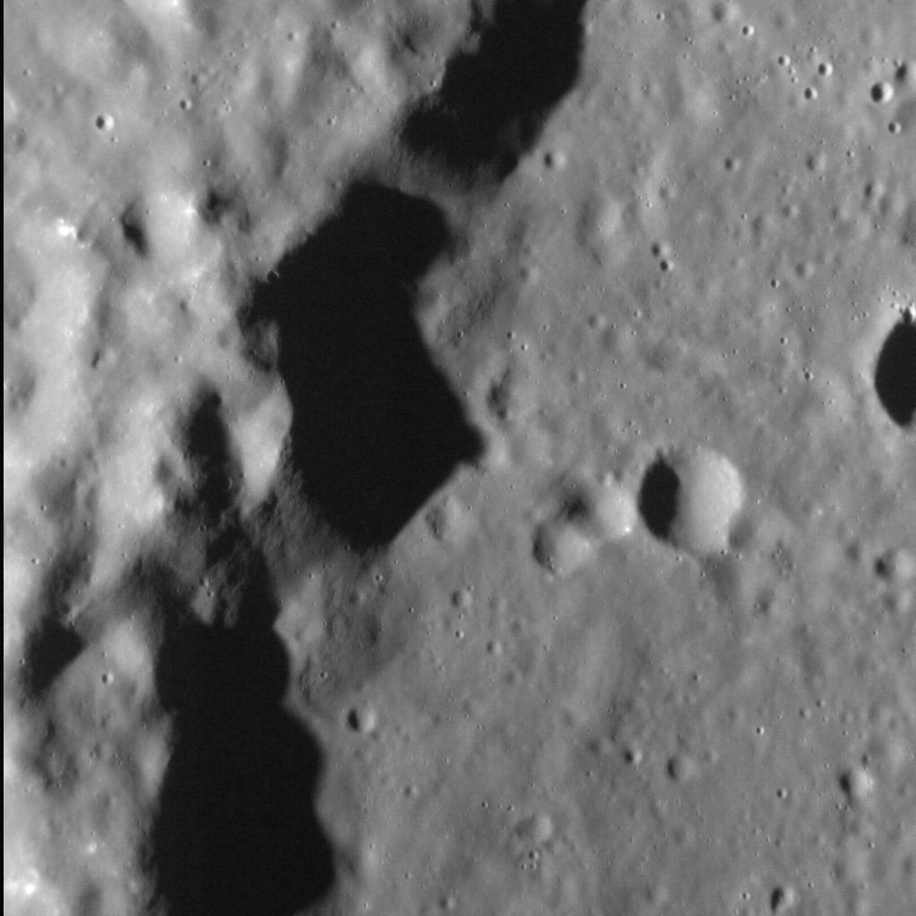
Of Interest: Wall terraces are landforms common to impact craters and basins across Mercury. The fault-bound cliff in this image forms part of the wall of an unnamed peak-ring basin (which also hosts hollows). The low-angle lighting in the scene creates dramatic shadows at the base of the rim terrace, which is almost 1.5 km (1 mi.) high.
This image was acquired as a high-resolution targeted observation. Targeted observations are images of a small area on Mercury's surface at resolutions much higher than the 200-meter/pixel morphology base map. It is not possible to cover all of Mercury's surface at this high resolution, but typically several areas of high scientific interest are imaged in this mode each week.
The MESSENGER spacecraft is the first ever to orbit the planet Mercury, and the spacecraft's seven scientific instruments and radio science investigation are unraveling the history and evolution of the Solar System's innermost planet. During the first two years of orbital operations, MESSENGER acquired over 150,000 images and extensive other data sets. MESSENGER is capable of continuing orbital operations until early 2015.
Image Mission Elapsed Time (MET): 3038847
Image ID: 3509826
Instrument: Narrow Angle Camera (NAC) of the Mercury Dual Imaging System (MDIS)
Center Latitude: 42.20°
Center Longitude: 292.10° E
Resolution: 22 meters/pixel
Scale: The field of view in this image is approximately 20 km (12 mi.) across
Incidence Angle: 73.6°
Emission Angle: 9.8°
Phase Angle: 63.8°
(North is down in this image.)
Of Interest: Wall terraces are landforms common to impact craters and basins across Mercury. The fault-bound cliff in this image forms part of the wall of an unnamed peak-ring basin (which also hosts hollows). The low-angle lighting in the scene creates dramatic shadows at the base of the rim terrace, which is almost 1.5 km (1 mi.) high.
This image was acquired as a high-resolution targeted observation. Targeted observations are images of a small area on Mercury's surface at resolutions much higher than the 200-meter/pixel morphology base map. It is not possible to cover all of Mercury's surface at this high resolution, but typically several areas of high scientific interest are imaged in this mode each week.
The MESSENGER spacecraft is the first ever to orbit the planet Mercury, and the spacecraft's seven scientific instruments and radio science investigation are unraveling the history and evolution of the Solar System's innermost planet. During the first two years of orbital operations, MESSENGER acquired over 150,000 images and extensive other data sets. MESSENGER is capable of continuing orbital operations until early 2015.
Credit: NASA/Johns Hopkins University Applied Physics Laboratory/Carnegie Institution of Washington
For information regarding the use of MESSENGER images, see the image use policy.