 Click on image to enlarge. | Mercury's North Polar RegionRelease Date: June 16, 2011 Topics: Image Compilations, Mosaics, NASA Press Conference 06/16/2011, Polar, Volcanism |
Date Presented: June 16, 2011, at a NASA press conference
Instrument: Wide Angle Camera (WAC) of the Mercury Dual Imaging System (MDIS)
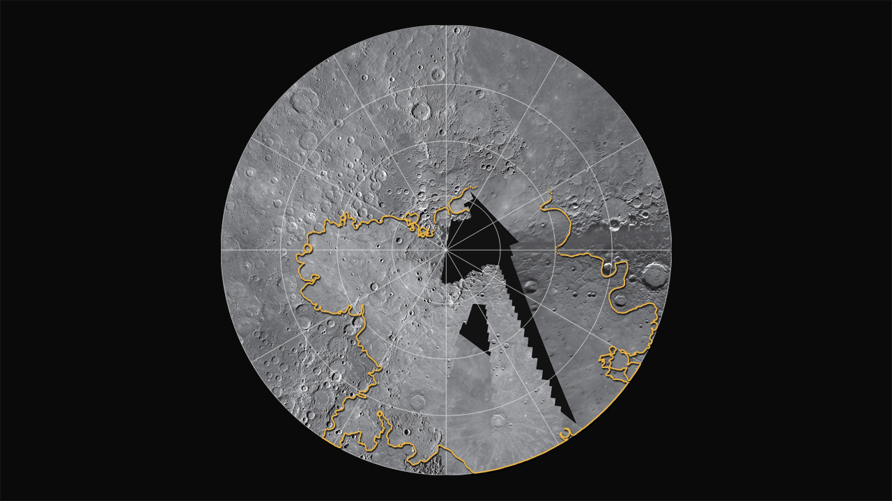
Of Interest: MESSENGER is currently filling in coverage of Mercury's north polar region, which was seen only partially during the Mariner 10 and MESSENGER flybys. Flyby images indicated that smooth plains were likely important in Mercury's northernmost regions. MESSENGER's orbital images show that the plains are among the largest expanses of volcanic deposits on Mercury, with thicknesses of several kilometers in many places. The estimated extent of these plains is outlined in yellow. This mosaic is a combination of flyby and orbital coverage in a polar stereographic projection showing latitudes from 50° to 90° N. The longitude at the 6 o'clock position is 0°.
The MESSENGER spacecraft is the first ever to orbit the planet Mercury, and the spacecraft's seven scientific instruments and radio science investigation are unraveling the history and evolution of the Solar System's innermost planet. Visit the Why Mercury? section of this website to learn more about the key science questions that the MESSENGER mission is addressing. During the one-year primary mission, MDIS is scheduled to acquire more than 75,000 images in support of MESSENGER's science goals.
Instrument: Wide Angle Camera (WAC) of the Mercury Dual Imaging System (MDIS)
Of Interest: MESSENGER is currently filling in coverage of Mercury's north polar region, which was seen only partially during the Mariner 10 and MESSENGER flybys. Flyby images indicated that smooth plains were likely important in Mercury's northernmost regions. MESSENGER's orbital images show that the plains are among the largest expanses of volcanic deposits on Mercury, with thicknesses of several kilometers in many places. The estimated extent of these plains is outlined in yellow. This mosaic is a combination of flyby and orbital coverage in a polar stereographic projection showing latitudes from 50° to 90° N. The longitude at the 6 o'clock position is 0°.
The MESSENGER spacecraft is the first ever to orbit the planet Mercury, and the spacecraft's seven scientific instruments and radio science investigation are unraveling the history and evolution of the Solar System's innermost planet. Visit the Why Mercury? section of this website to learn more about the key science questions that the MESSENGER mission is addressing. During the one-year primary mission, MDIS is scheduled to acquire more than 75,000 images in support of MESSENGER's science goals.
Credit: NASA/Johns Hopkins University Applied Physics Laboratory/Carnegie Institution of Washington
For information regarding the use of MESSENGER images, see the image use policy.