May 24, 2011
Altimetry Is Defining Mercury's Shape
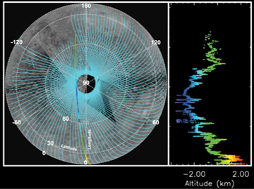
Figure 1. MLA coverage (left) of Mercury as May 21, 2011, shown as a polar orthographic projection extending to the equator. The altimetric profile (obtained on April 30, 2011) for the MLA track highlighted on the left is shown in detail on the right. The length of this profile is about 6000 km (or about 3700 miles).
MESSENGER’s Mercury Laser Altimeter (MLA) in its first 2 months of operation has already built up a grid of ground tracks that span most of Mercury’s surface north of the equator (Figure 1). These data will provide a very good measure of the shape of the planet’s northern hemisphere. The shape of a planet carries a record of all of the interior dynamical and geological processes that have modified the surface.
Signals from MLA’s laser reflected from the surface can be recovered whenever the spacecraft is within a range of about 1,800 km (about 1,100 miles) from the ground track. Because of MESSENGER’s highly elliptical orbit, MLA can make measurements only for a portion of each orbit approximately centered on closest approach (Figure 2). By far the most accurate instrument on MESSENGER for determining the shape of Mercury, MLA is yielding precise topographic measurements of Mercury’s northern hemisphere, but other techniques must be employed to measure the shape of the southern hemisphere. These complementary techniques include the creation of three-dimensional terrain models from stereo images obtained with MESSENGER’s Mercury Dual Imaging System (MDIS), radio occultations, and MDIS profiling of the planet’s limb.
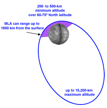
Figure 2. MLA can range to Mercury only when the spacecraft is less than approximately 1800 km from the surface. For MESSENGER's elliptical orbit, shown schematically here, this condition is met over Mercury's northern hemisphere (purple shading).
The MESSENGER spacecraft conducts stereo imaging by photographing regions of Mercury’s surface at more than one viewing geometry. The first step in the conversion of stereo images to topographic models is to identify common points in each image of a given area. Then, for each image a line of sight can be constructed from the camera location to each common point. The intersection of the lines of sight to a given common point from two viewing geometries constrains the position of the point on the surface of a topographic model. With many common points, one can reconstruct the shape of the area imaged.
Radio occultations provide an independent means to measure the shape of the planet. Occultations occur when the planet blocks radio waves sent from the MESSENGER spacecraft to Earth. By measuring carefully the times of disappearance or appearance of the radio signal at the beginning or end of an occultation, the science team can determine the local radius of the planet.
The shape of Mercury’s southern hemisphere can also be determined by capturing images of the planet’s limb (the outer edge of the sunlit planet) with MDIS. Limb imaging allows the shape of the surface to be seen because of the contrast between the bright edge of the planet and the darkness of space.
Because the MLA data are highly accurate, they can be used to “calibrate” data obtained by other techniques. For example, in Mercury’s northern hemisphere, a precise measurement from MLA can be used to fix portions of a topographic map created from stereo imaging or to sharpen estimates of local radius obtained from occultations or limb profiling. Such results can then be extrapolated to the southern hemisphere, where MLA data are not available.
By combining stereo-derived topographic models, radio occultation measurements, and limb profiles with MLA observations, the MESSENGER science team will determine accurately the global shape of Mercury.

