In April 2015, the MErcury Surface, Space ENvironment, GEochemistry, and Ranging (MESSENGER) spacecraft will complete more than 4 years of operations in orbit around Mercury. This past summer, the team launched a low-altitude observation campaign to acquire the highest-resolution images ever obtained of Mercury, enabling scientists to search for volcanic flow fronts, small-scale tectonic features, layering in crater walls, locations of impact melt, and new aspects of hollows – detailed views that are providing a new understanding of Mercury’s geological evolution. Scientists discuss new findings from the low-altitude campaign with the media at the 46th Lunar and Planetary Science Conference, which will be held at The Woodlands Waterway Marriott Hotel and Convention Center, The Woodlands, Texas.
Presenter #1 |
Sean C. Solomon, MESSENGER Principal Investigator
Director of Columbia University's Lamont-Doherty Earth Observatory, Palisades. N.Y.
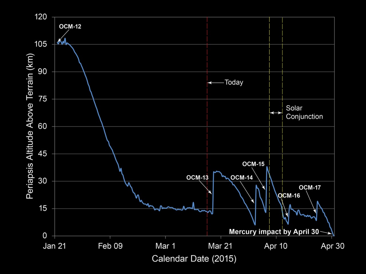
Figure 1.1
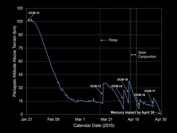
Figure 1.1 Evolution of the altitude at closest approach for MESSENGER's thrice-daily orbits of Mercury, from the completion of the most recent orbit-correction maneuver (OCM-12) on January 21 until the planned end of mission on April 30. Five additional OCMs are scheduled between now and late April.
|
|
Presenter #2 |
David T. Blewett, MESSENGER Participating Scientist
Planetary Scientist, The Johns Hopkins University Applied Physics Laboratory, Laurel, Md.
|
Presenter #3 |
Larry R. Nittler, MESSENGER Deputy Principal Investigator
Cosmochemist, Department of Terrestrial Magnetism, Carnegie Institution of Washington, Washington, D.C.
Figure 3.1
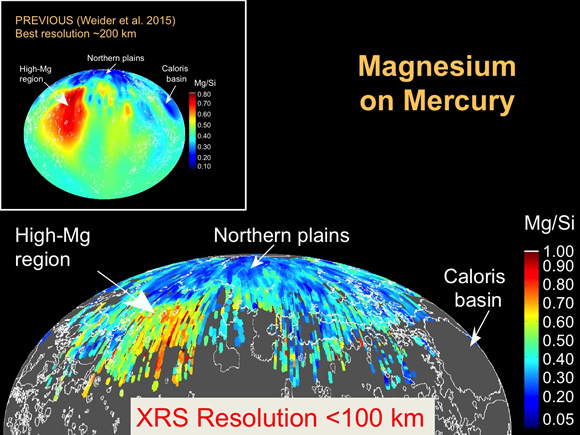
Figure 3.1 Map of Mg/Si ratio by weight on Mercury from MESSENGER X-Ray Spectrometer measurements acquired at a spatial resolution better than 100 km, compared with a published map of earlier data (Weider et al., 2015, inset), for which the best resolution is about 200 km. The higher-resolution map reveals variability on smaller scales and over a greater range of compositions. Smooth plains deposits are outlined in white.
|
|
Figure 3.2
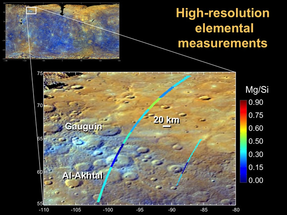
Figure 3.2 Very-high-resolution XRS measurements of Mg/Si overlaid on enhanced color map of Mercury near Gauguin and Al-Akhtal craters. Relatively fresh material appears cyan in the enhanced-color representation, and the XRS data clearly show a distinct composition for this material compared with its surroundings, as well as other elemental variability on a few-kilometer scale.
|
|
Figure 3.3
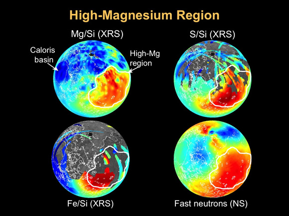
Figure 3.3 Maps of Mercury in orthographic projection (centered on 50°N, -120°E). Low-altitude XRS measurements (Frank et al., 2015) reveal that the highest sulfur (~3 wt%) and iron concentrations (2-3 wt%) are found within the high-Mg region, where the highest concentration of Ca on Mercury, and lowest Al contents, are also found. A map of high-energy (“fast”) neutrons (Lawrence et al, 2015; bottom right) emitted by the planet indicates that the highest count rates are also from the high-Mg region. These neutrons are sensitive to Fe and thus serve as a proxy for iron abundance with better spatial coverage than direct measurements by XRS, which depend on sporadic large solar flares. The unusual composition of the high-Mg region and the relatively thin crust in this region suggest that it may be the remains of an ancient and highly degraded impact basin.
|
|
Presenter #4 |
Thomas R. Watters, MESSENGER Participating Scientist
Senior Scientist, Center for Earth and Planetary Studies of the National Air and Space Museum, Smithsonian Institution, Washington, D.C.
Figure 4.1
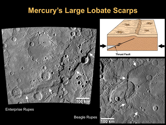
Figure 4.1 MESSENGER has confirmed that the contraction of Mercury has resulted in a global array of lobate scarps, tectonic landforms that are the surface expression of thrust faults (top right). Lobate thrust fault scarps such as Enterprise Rupes (upper left) and Beagle Rupes (lower right) are large, often hundreds of kilometers long, and display hundreds to thousands of meters of relief. Enterprise Rupes, about 1000 km long and with over 3 km of relief, is the largest lobate scarp on Mercury.
|
|
Figure 4.2
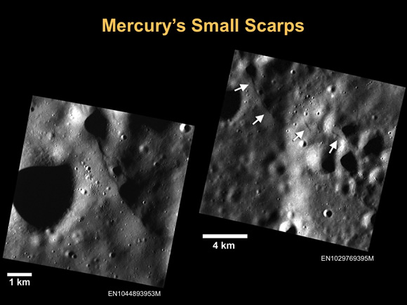
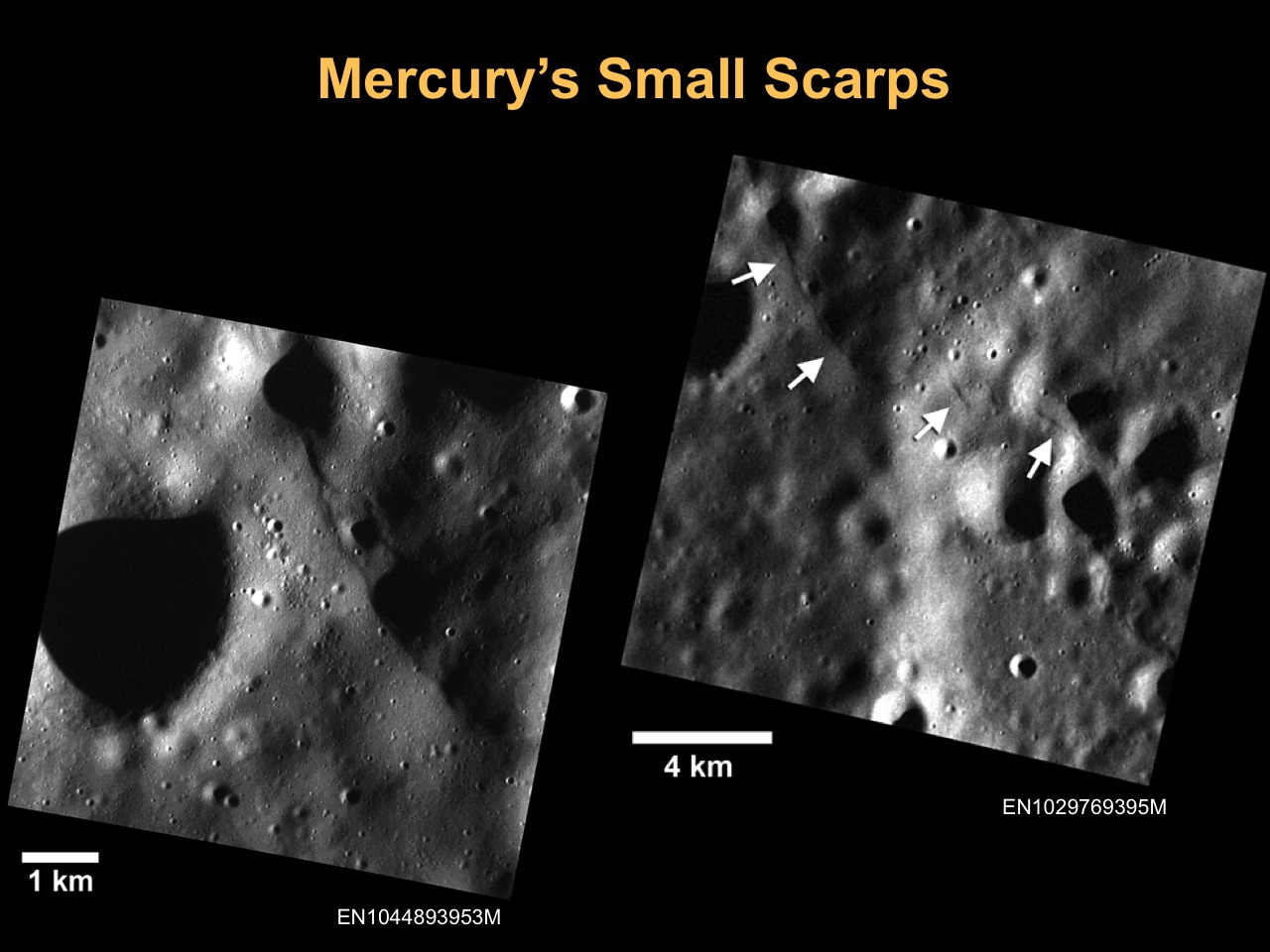
Figure 4.2 Images obtained after lowering MESSENGER’s altitude have revealed a population of small fault scarps (upper right, white arrows) that can be more than an order of magnitude smaller in size than their larger counterparts. These small scarps are less than 10 km in length and have only tens of meters of relief. They are comparable in size and morphology to small fault scarps imaged on the Moon by the Lunar Reconnaissance Orbiter. The higher-resolution image at lower left shows a close-up of one of the scarps evident in the upper right image (upper two arrows).
|
|
Figure 4.3
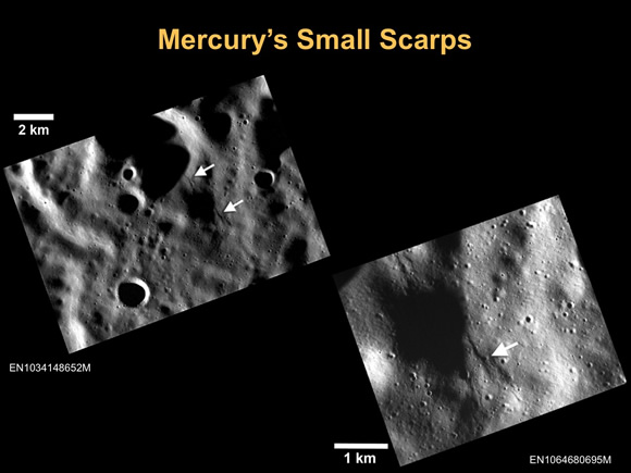
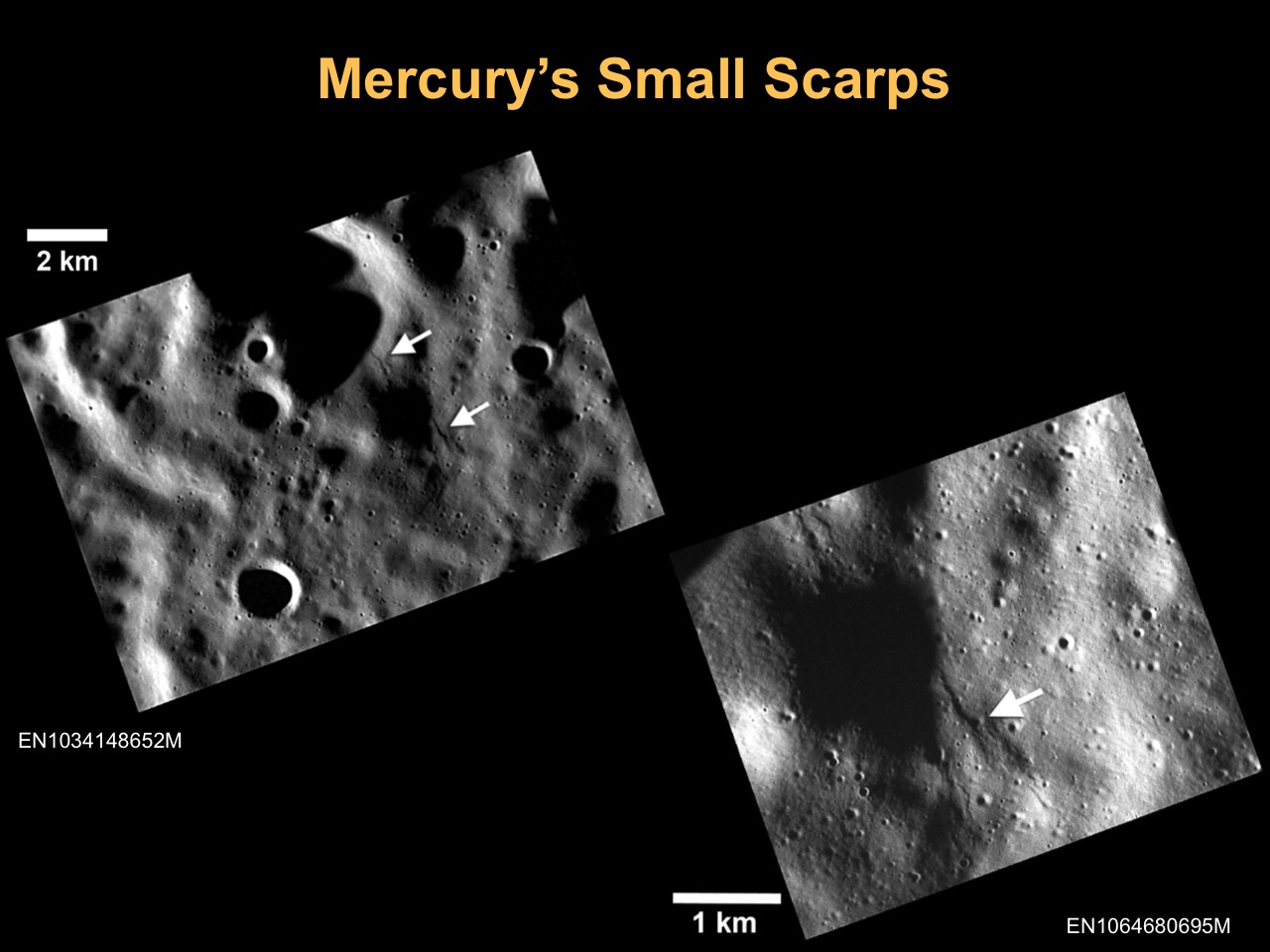
Figure 4.3 Mercury’s small scarps, like small scarps on the Moon, often occur in clusters (upper left, white arrows). These scarps frequently crosscut young impact crater with diameters less than 100 m (lower right, white arrow). Crosscutting relations with craters less than 100 m in diameter suggest that the small scarps formed no more than 800 Myr ago. The higher-resolution image at lower right shows a close-up of the scarps seen in the upper left image.
|
|
Figure 4.4
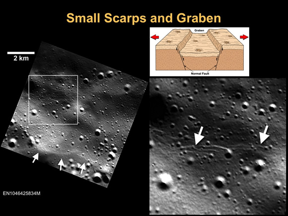
Figure 4.4 Small graben, narrow linear troughs, have been found associated with small scarps (upper left, white arrows) on Mercury and the Moon. These graben (lower right, white arrows) likely resulted from the bending and extension of the upper crust in response to scarp formation (upper right) and are only tens of meters wide. On the basis of the rate of degradation and infilling of small troughs on the Moon by continuous meteoroid bombardment, small lunar graben and their associated scarps are less than 50 Myr old. It is likely that Mercury’s small graben and their associated scarps are younger still, because the cratering rate on Mercury is a factor of ~3 greater than on the Moon.
|
|
Presenter #5 |
Nancy L. Chabot, Instrument Scientist for MESSENGER’s Mercury Dual Imaging System (MDIS)
Planetary Scientist, The Johns Hopkins University Applied Physics Laboratory, Laurel, Md.
Figure 5.1a
Figure 5.1b
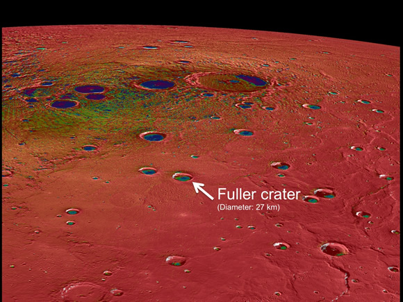
Figure 5.1c
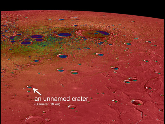
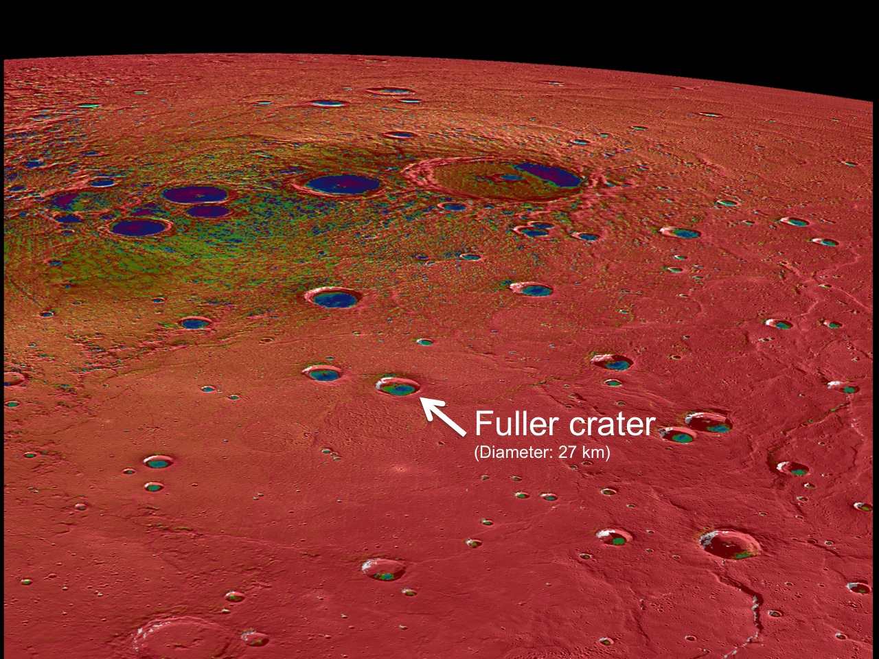
Figure 5.1a-c Mercury’s north polar region, colored by the maximum biannual surface temperature, which ranges from >400 K (red) to 50 K (purple). As expected for the Solar System’s innermost planet, areas of Mercury’s surface that are sunlit reach high temperatures. In contrast, some craters near Mercury’s poles have regions that remain permanently in shadow, and in these regions even the maximum temperatures can be extremely low. Evidence from MESSENGER and Earth-based observations indicate that water ice deposits are present in these cold craters. The craters nearest Mercury’s poles have surface temperatures <100 K, and water ice is stable on the surface. However, many craters near but somewhat farther from Mercury’s poles have cold, permanently shadowed interiors, but the maximum temperature is too high for water ice to persist at the surface. In these craters, such as the two indicated in this figure, water ice is present but is buried beneath a thin, low-reflectance volatile layer likely consisting of organic-rich material. (Fuller crater: 27-kilometer diameter; 82.63°N, 317.35°E; unnamed crater: 18-kilometer diameter; 80.30°N, 293.47°E)
|
|
Figure 5.2a
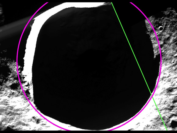
Figure 5.2b

Figure 5.2c

Figure 5.2d

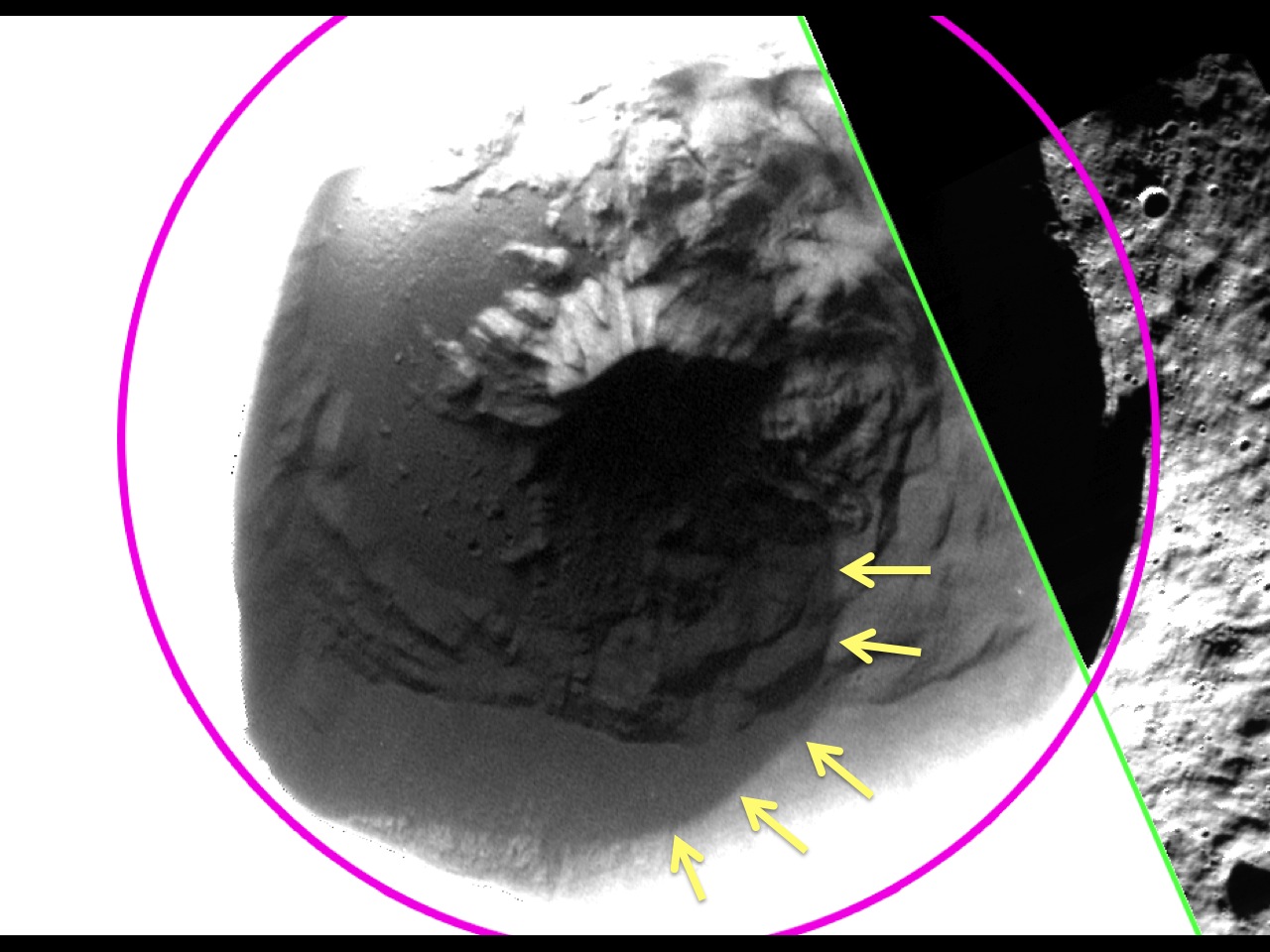
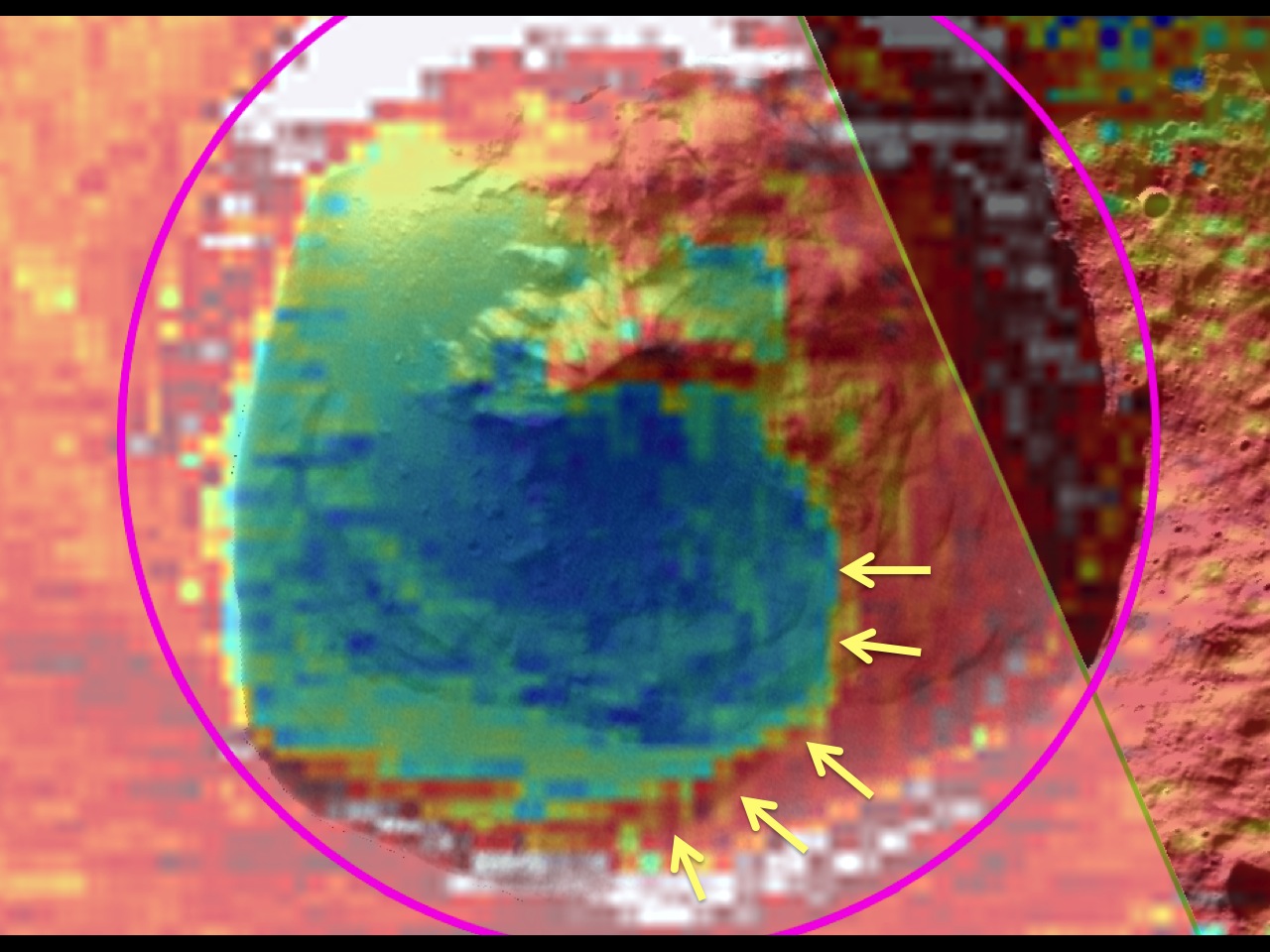
Figure 5.2a-d MESSENGER’s low-altitude campaign enabled imaging of Fuller crater by the Mercury Dual Imaging System (MDIS) in greater detail than previously possible. The top panel shows an image of Fuller, with the crater rim outlined in pink and the edge of a low-altitude broadband MDIS image in green. The second panel applies a different stretch to the MDIS broadband image in the first panel, revealing details of the shadowed surface inside the crater. In particular, as highlighted with yellow arrows in the third panel, the image reveals a region inside Fuller that is lower in reflectance. The edge of the low-reflectance region has a sharp and well-defined boundary, even when imaged at 46 m/pixel, suggesting that the low-reflectance material is sufficiently young to have preserved a sharp boundary against lateral mixing by impact cratering. The low-reflectance region agrees well with the temperature model predictions, as shown in the last panel. The model for surface and near-surface temperature within Fuller crater predicts a region that is sufficiently cold to host long-lived water ice beneath the surface but too hot to support water ice at the surface (blue and green regions). The low-reflectance region revealed in the images matches the characteristics expected for a lag deposit of volatile, organic-rich material that overlies the water ice.
(Fuller crater: 27-kilometer diameter; 82.63°N, 317.35°E)
|
|
Figure 5.3a
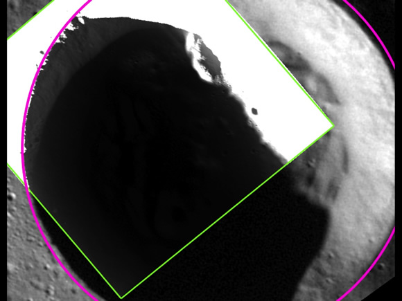
Figure 5.3b
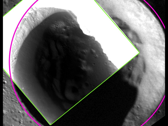
Figure 5.3c
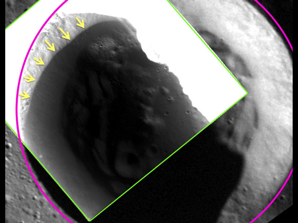
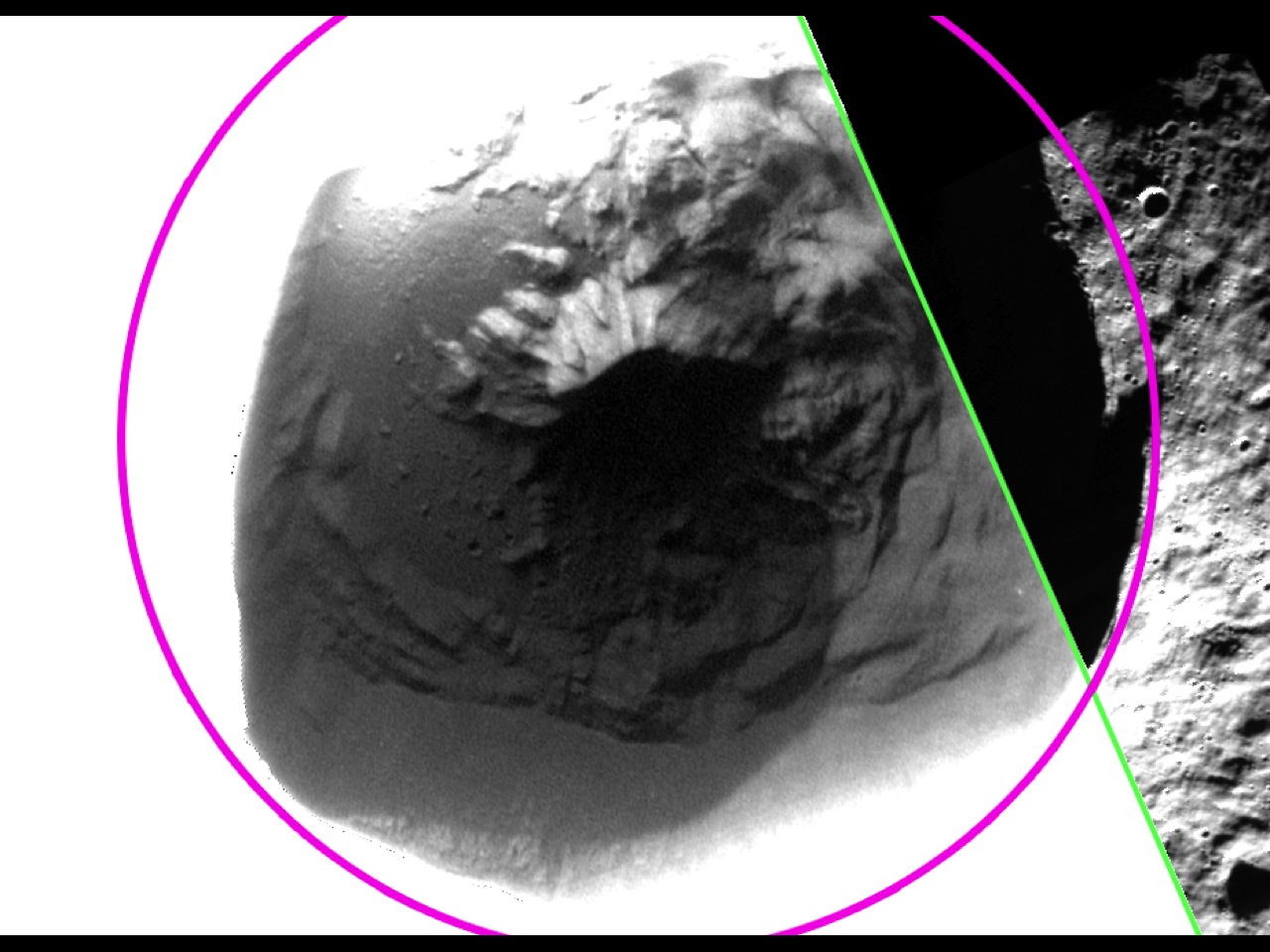
Figure 5.3a-c MESSENGER’s low-altitude campaign enabled imaging of shadowed polar craters by the Mercury Dual Imaging System (MDIS) in greater detail than previously possible. The image shown here was acquired at 24 m/pixel, the highest resolution that has been obtained for any of Mercury’s shadowed polar craters. The first panel shows a view of an unnamed crater in Mercury’s north polar region, with the crater rim outlined in pink and the edge of the 24-meter/pixel, low-altitude broadband MDIS image in green. In the second panel, a different stretch has been applied to the MDIS broadband image in the first panel, revealing details of the shadowed surface inside the crater. In particular, as highlighted with yellow arrows in the third panel, the image reveals a region inside the crater that has a lower reflectance. The edge of the low-reflectance region has a sharp and well-defined boundary, even as imaged at this highest resolution of 24 m/pixel. The sharp boundary suggests that the low-reflectance material is sufficiently young to have preserved a sharp boundary against lateral mixing by impact craters. The sharp boundary matches the location predicted by temperature models for the stability of a surficial layer of volatile, organic-rich material tens of centimeters thick that overlies a thicker layer of water ice.
(An unnamed crater: 18-kilometer diameter; 80.30°N, 293.47°E)
|
|
The MESSENGER Press Briefing took place on Monday, March 16, 2015, at 12 p.m. Central.