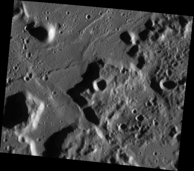
 Click on image to enlarge. | The Caloris MontesRelease Date: May 17, 2011 Topics: Caloris, |
Date acquired: May 05, 2011
Image Mission Elapsed Time (MET): 213066802
Image ID: 214595
Instrument: Narrow Angle Camera (NAC) of the Mercury Dual Imaging System (MDIS)
Center Latitude: 17.60°
Center Longitude: 176.4° E
Resolution: 163 meters/pixel
Scale: Image is approximately 95 km (59 miles) across
Incidence Angle: 74.4°
Emission Angle: 30.9°
Phase Angle: 105.4°
Of Interest: The Caloris Montes are the ring of mountainous peaks that make up the rim of the Caloris basin. Shown here is the southeastern portion of the rim, first seen by Mariner 10. This month MESSENGER is getting its first orbital look at Caloris, and its first images of the basin with the Sun low in the sky (high incidence angles), allowing for unprecedented views of the topographic features of one of the largest basins in the Solar System.
This image was acquired as part of MDIS's high-resolution surface morphology base map. The surface morphology base map will cover more than 90% of Mercury's surface with an average resolution of 250 meters/pixel (0.16 miles/pixel or 820 feet/pixel). Images acquired for the surface morphology base map typically have off-vertical Sun angles (i.e., high incidence angles) and visible shadows so as to reveal clearly the topographic form of geologic features.
The MESSENGER spacecraft is the first ever to orbit the planet Mercury, and the spacecraft's seven scientific instruments and radio science investigation are unraveling the history and evolution of the Solar System's innermost planet. Visit the Why Mercury? section of this website to learn more about the key science questions that the MESSENGER mission is addressing. During the one-year primary mission, MDIS is scheduled to acquire more than 75,000 images in support of MESSENGER's science goals.
Credit: NASA/Johns Hopkins University Applied Physics Laboratory/Carnegie Institution of Washington
For information regarding the use of MESSENGER images, see the image use policy.