 Click on image to enlarge. | One Year of Spectral MappingRelease Date: April 12, 2012 Topics: Global Views, MASCS |
Date Created: April 2, 2012
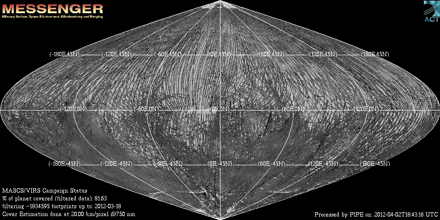
Instrument: Visible and Infrared Spectrograph (VIRS) of the MESSENGER Atmosphere and Surface Composition Spectrometer (MASCS)
Center Latitude: 0°
Center Longitude: 0° E
Resolution: 20 km/pixel
Of Interest: This sinusoidal equal area projection map shows the ground coverage on Mercury by the MASCS VIRS instrument. The coverage tracks are shaded by brightness measured by VIRS at 750 nm. A pixel is counted as 'observed' if any portion of it is covered by a VIRS footprint. By this method, over 81% of the surface has been observed in the primary mission of MESSENGER, with more to come in the extended mission. In locations where multiple VIRS footprints cover the same area, the footprint with the best viewing geometry (usually the lowest incidence angle) is counted for coverage, and for making spectral maps of the surface. These spectral maps are helping the MESSENGER team understand the composition and mineralogy of Mercury's surface.
The MESSENGER spacecraft is the first ever to orbit the planet Mercury, and the spacecraft's seven scientific instruments and radio science investigation are unraveling the history and evolution of the Solar System's innermost planet. Visit the Why Mercury? section of this website to learn more about the key science questions that the MESSENGER mission is addressing. During the one-year primary mission, MESSENGER acquired 88,746 images and extensive other data sets. MESSENGER is now in a yearlong extended mission, during which plans call for the acquisition of more than 80,000 additional images to support MESSENGER's science goals.
Credit: NASA/Johns Hopkins University Applied Physics Laboratory/Carnegie Institution of Washington
For information regarding the use of MESSENGER images, see the image use policy.