May 10, 2011
The Imaging Campaigns of MESSENGER's Mercury Dual Imaging System
As the first spacecraft to orbit the planet Mercury, MESSENGER has the opportunity to make many observations of the Solar System's innermost planet that had not previously been possible. Each of MESSENGER’s eight science investigations has a one-year data collection plan that has been carefully designed to meet the goal of maximizing the science return for the mission. MESSENGER's Mercury Dual Imaging System (MDIS) is composed of two cameras, a wide-angle camera (WAC) and a narrow-angle camera (NAC). MDIS is scheduled to acquire more than 75,000 WAC and NAC images during the one-year orbital mission in support of MESSENGER's science goals. A range of imaging campaigns achieves a balance between globally mapping the entire surface of Mercury and obtaining targeted higher-resolution images in support of specific science goals. Together, MDIS's imaging campaigns will provide a new view of Mercury and will address one of the mission's main science questions: What is the geologic history of Mercury?
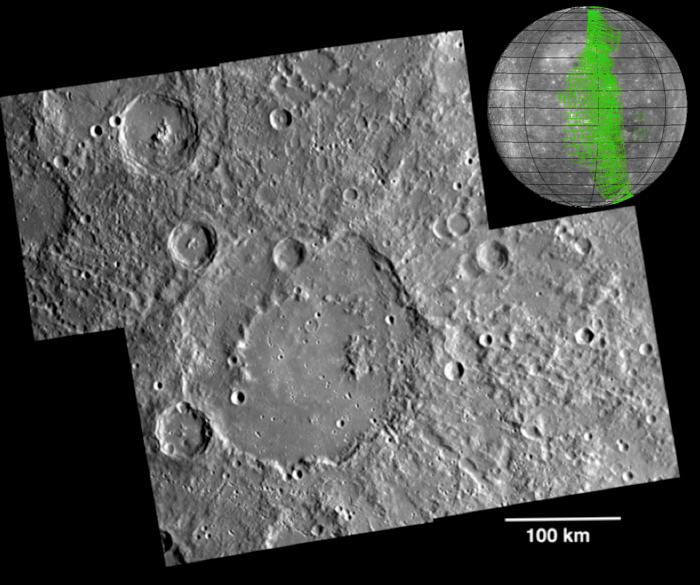
Surface Morphology Base Map
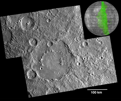
Figure 1. A portion of the surface morphology base map. The mosaic is centered at 22.63°S, 219.71°E, and has a resolution of 216 m/pixel. The large crater in the center is Valmiki (210 km diameter). Inset globe: example of planned base map image coverage during a typical week, showing how mosaics of large regions of the surface are built up from numerous individual images.
During the first 176 days of the orbital mission, equal to one solar day on Mercury, MDIS will acquire images to produce a high-resolution base map for surface morphology (morphology is the term given to the shape and texture of the surface). This map will cover more than 90% of Mercury's surface at an average resolution of 250 m/pixel (0.16 miles/pixel or 820 feet/pixel) or better. At this resolution, features about 1 km in horizontal scale are recognizable in the images. Images acquired for the surface morphology base map have off-vertical solar illumination and visible shadows so as to reveal clearly the topographic form of geologic features. Because of MESSENGER's highly elliptical orbit, the spacecraft passes close to the surface at high northern latitudes but is far above the southern hemisphere, so both the NAC and the WAC are being used to construct the global base map. For the southern hemisphere, images are obtained with the NAC, which has a 1.5° field of view and can acquire images at seven times greater resolution than the WAC. For the northern hemisphere, when the spacecraft is closer to and moving faster over the surface, the WAC is used, because its 10.5° field of view enables good image coverage. Images from both the NAC and the WAC will be mosaicked together to produce the global map. Shown in Figure 1 is an example mosaic of four images acquired as part of the surface morphology campaign.
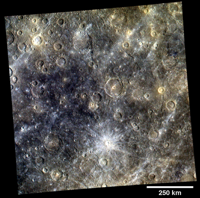
Color Base Map
In addition to the surface morphology base map, MDIS is currently acquiring a color base map during the mission's first 176 days. The color base map is composed of WAC images taken through eight different narrow-band color filters and will cover more than 90% of Mercury's surface at an average resolution of 1 km/pixel (0.6 miles/pixel) or better. In contrast to the imaging conditions best suited for seeing surface topography, the highest-quality color images of Mercury's surface are obtained when both the spacecraft and the Sun are overhead and shadows are limited. The eight different color filters of the WAC that are used to create the color base map have central wavelengths of 430, 480, 560, 630, 750, 830, 900, and 1000 nm. The images acquired through these narrow-band filters are combined to create color images that accentuate color differences on Mercury's surface. As an example, the image in Figure 2 was created by using three images acquired as part of the color base map with the central wavelengths of 1000, 750, and 430 nm displayed in red, green, and blue, respectively.
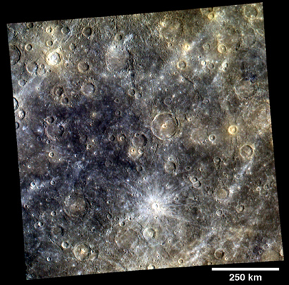
Figure 2. A portion of the color base map. The image is centered at 3.46°S, 275.92°E, and has a resolution of 960 m/pixel. The bright, rayed crater is Snorri (21 km diameter).
Stereo Base Map
After the surface morphology base map is acquired during the first Mercury solar day, a second, complementary near-global map, called the stereo base map, will be acquired during the second Mercury solar day of MESSENGER’s one-year orbital mission. The stereo base map will be used in combination with the surface morphology base map to create high-resolution stereo views of Mercury's surface at an average resolution of 250 m/pixel (0.16 miles/pixel or 820 feet/pixel) or better. As with the surface morphology base map, images are acquired under non-vertical solar illumination, so that shadows accentuate the topography of the surface. In addition, the stereo basemap images are acquired under viewing angles that differ from those for the morphology base map by about 20°, allowing stereo information about the surface to be determined. As the mission is currently in the first Mercury solar day, no images have yet been acquired in support of the stereo base map. However, different viewing conditions during MESSENGER's second and third Mercury flybys allowed stereo information to be obtained for a portion of Mercury's surface at an image resolution of 500 m/pixel. View this example of Rembrandt to see the type of stereo data that will be derived from the two sets of image base maps.

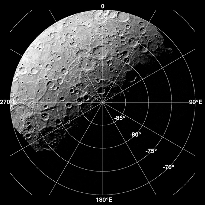
Figure 3. Example of south polar monitoring. The resolution is 1.5 km/pixel.
South Polar Monitoring
In addition to the three global base maps, there is an MDIS imaging campaign to monitor the south polar region of Mercury. By imaging the south polar region once every four MESSENGER orbits (once every two Earth days) as illumination conditions change, features that were in shadow on earlier orbits can be discerned and any permanently shadowed areas can be identified over one Mercury solar day. Identifying areas of permanent shadow are of interest to understand the unusual materials at Mercury's poles and whether these highly radar-reflective materials consist of water ice. During MESSENGER's one-year mission, the WAC is used to monitor the polar region south of 70°S at 1.5 km/pixel for the first Mercury solar day. On the second Mercury solar day, the NAC will be used for imaging the polar region south of 85°S at 300 m/pixel. An example WAC image acquired as part of MDIS's south polar monitoring campaign is shown in Figure 3.

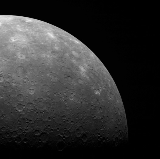
Figure 4. Example of limb imaging. The image is centered at 58.57°S, 308.10°E, and has a resolution of 1.5 km/pixel.
Limb Imaging
Once per week, MDIS captures images of Mercury's limb (the edge of the sunlit planet with space), with an emphasis on imaging the southern hemisphere limb. An example of one of those limb images is shown in Figure 4. The spacecraft was high above Mercury's south polar region when capturing this image. However, even when the spacecraft is at its highest altitude above Mercury, a single WAC image cannot capture the entire limb of Mercury. Consequently, two images are taken and mosaicked together to image Mercury's entire limb. These limb images will provide information about Mercury's shape and will complement measurements of topography made by the Mercury Laser Altimeter (MLA) of Mercury's northern hemisphere.
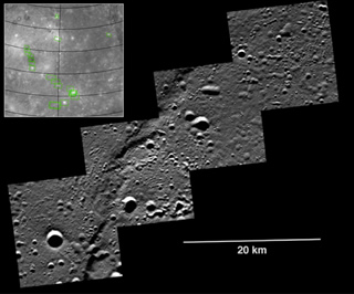
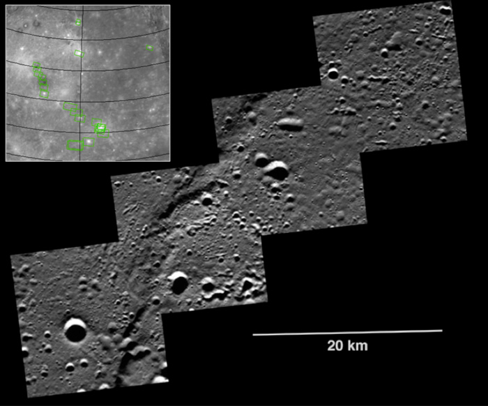
Figure 5. Example of a targeted observation. The image mosaic is centered at 83.06°N, 290.05°E, and has a resolution of 15 m/pixel. The inset shows the locations of a number of planned targeted observations within the floor of the Caloris basin.
Targeted Observations
MDIS also acquires targeted images of small areas on Mercury's surface at resolutions much higher than those of the morphology, stereo, or color base maps. It is not possible to cover all of Mercury's surface at such high resolutions during MESSENGER's one-year primary mission, but several areas of high scientific interest are generally imaged in this mode each week. Additionally, as new features of particular science interest are imaged from orbit, targets are added to a database list and will be imaged if possible at higher resolution by MDIS, or with multiple instruments, the next time that area of Mercury is in view from the spacecraft. Figure 5 shows a mosaic of four images from a targeted observation acquired at 15 m/pixel, a resolution that is more than an order of magnitude improvement over the surface morphology base map. These ultra-high-resolution images are revealing Mercury's surface in unprecedented detail.
Calibrations
In addition to the science imaging campaigns described above, MDIS also acquires a few images each week in support of calibration of the instrument. Some of these images are of star fields, to verify the pointing of the camera and to assess any changes in instrument characteristics during the mission. These star images resemble those acquired in support of the vulcanoid search effort, carried out during MESSENGER's journey prior to orbit insertion. Other calibration images include repeated imaging of the same portion of Mercury's surface under different lighting and viewing geometries. These image sets provide information about the photometric corrections that must be applied to compare images acquired under a range of lighting and viewing conditions.