 Click on image to enlarge. | Breaking MercuryRelease Date: March 6, 2013 Topics: Scarps and Rupes, Tectonics |
Center Latitude: 58.18°
Center Longitude: 307.69° E
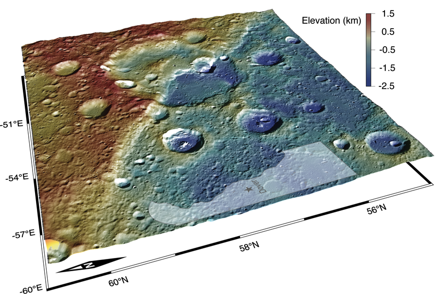
Scale: The crater that is being cross-cut by this scarp is about 108 km ( 67 mi.) in diameter.
Of Interest:The figure above shows an oblique view of a 280 km long scarp. The color scale on this figure represents elevation in which red is high and blue is low. This scarp is interpreted to be a surface-breaking thrust fault. Thrust faults are surface manifestations of the shrinkage of the planet resulting from the cooling of its interior. Notice that the terrain on the left side of the scarp stands about 2 km higher than that of the right side of the scarp. To give you a sense of the scale of this scarp, the state of Delaware has been superposed on the figure.
The MESSENGER spacecraft is the first ever to orbit the planet Mercury, and the spacecraft's seven scientific instruments and radio science investigation are unraveling the history and evolution of the Solar System's innermost planet. Visit the Why Mercury? section of this website to learn more about the key science questions that the MESSENGER mission is addressing. During the one-year primary mission, MESSENGER acquired 88,746 images and extensive other data sets. MESSENGER is now in a yearlong extended mission, during which plans call for the acquisition of more than 80,000 additional images to support MESSENGER's science goals.
Center Longitude: 307.69° E
Scale: The crater that is being cross-cut by this scarp is about 108 km ( 67 mi.) in diameter.
Of Interest:The figure above shows an oblique view of a 280 km long scarp. The color scale on this figure represents elevation in which red is high and blue is low. This scarp is interpreted to be a surface-breaking thrust fault. Thrust faults are surface manifestations of the shrinkage of the planet resulting from the cooling of its interior. Notice that the terrain on the left side of the scarp stands about 2 km higher than that of the right side of the scarp. To give you a sense of the scale of this scarp, the state of Delaware has been superposed on the figure.
The MESSENGER spacecraft is the first ever to orbit the planet Mercury, and the spacecraft's seven scientific instruments and radio science investigation are unraveling the history and evolution of the Solar System's innermost planet. Visit the Why Mercury? section of this website to learn more about the key science questions that the MESSENGER mission is addressing. During the one-year primary mission, MESSENGER acquired 88,746 images and extensive other data sets. MESSENGER is now in a yearlong extended mission, during which plans call for the acquisition of more than 80,000 additional images to support MESSENGER's science goals.
Credit: NASA/Johns Hopkins University Applied Physics Laboratory/Carnegie Institution of Washington
For information regarding the use of MESSENGER images, see the image use policy.