 Click on image to enlarge. | Tectonic Complexity in Mercury's Impact FeaturesRelease Date: March 20, 2013 Topics: Caloris, LPSC Presentations, Rembrandt, Scarps and Rupes, Smooth Terrain, Tectonics, Volcanism |
Date released: February 1, 2013
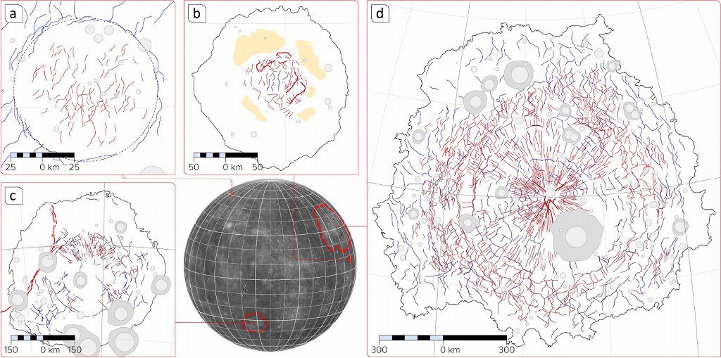
Center Latitude: (a) 60.3°, (b) 7.8°, (c) -33.5°, (d) 30°
Center Longitude: (a) 36.7° E, (b) 169.6° E, (c) 88°E, (d) 161°E
Projection: Orthographic
Reference: From abstract #1261 by Paul K. Byrne and coauthors at the 44th Lunar and Planetary Science Conference
Of Interest: Mercury's surface is covered with impact craters, many of which have been flooded by lavas. A subset of flooded impact features host tectonic structures ° graben (shown in red in the figure above) and ridges and scarps (blue) ° that formed during or after volcanic infilling. Such impact features range from so-called "ghost craters" through medium-sized basins such as Mozart, to the largest basins on Mercury, including Rembrandt and the mighty Caloris. Mapping these structures, and so characterizing their nature and spatial and temporal distributions, helps scientists understand the processes responsible for the tectonic complexity within volcanically infilled craters and basins on Mercury.
The results of the tectonic mapping shown here was presented in the abstracts of the 44th Lunar and Planetary Science Conference, which is being held this week in The Woodlands, Texas. In total, MESSENGER team members are presenting 33 papers at this conference.
The MESSENGER spacecraft is the first ever to orbit the planet Mercury, and the spacecraft's seven scientific instruments and radio science investigation are unraveling the history and evolution of the Solar System's innermost planet. During the first two years of orbital operations, MESSENGER acquired over 150,000 images and extensive other data sets. MESSENGER is capable of continuing orbital operations until early 2015.
Credit: NASA/Johns Hopkins University Applied Physics Laboratory/Carnegie Institution of Washington
For information regarding the use of MESSENGER images, see the image use policy.