 Click on image to enlarge. | The HillsRelease Date: May 5, 2014 |
Date acquired: March 25, 2014
Image Mission Elapsed Time (MET): 38066727
Image ID: 6000245
Instrument: Narrow Angle Camera (NAC) of the Mercury Dual Imaging System (MDIS)
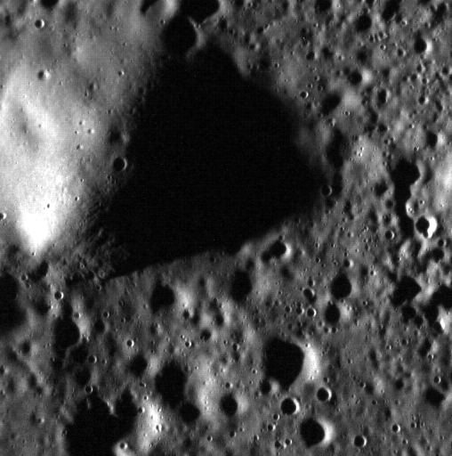
Center Latitude: 83.92°
Center Longitude: 242.3° E
Resolution: 13 meters/pixel
Scale: This image is approximately 7 km (4.3 mi.) across.
Incidence Angle: 84.0°
Emission Angle: 1.9°
Phase Angle: 82.0°
Of Interest: This hill lies towards the edge of Mercury's expansive northern plains. The Sun was low in the sky (high incidence angle) when this image was acquired, resulting in a shadow approximately 3.3 km (2 mi.) long. Using trigonometry and knowledge of the incidence angle, the height of the hill can be calculated: ~340 m (~0.2 mi.). This hill might be the remnants of an old crater rim that was subsequently flooded. North is to the right of this image.
This image was acquired as a high-resolution targeted observation. Targeted observations are images of a small area on Mercury's surface at resolutions much higher than the 200-meter/pixel morphology base map. It is not possible to cover all of Mercury's surface at this high resolution, but typically several areas of high scientific interest are imaged in this mode each week.
The MESSENGER spacecraft is the first ever to orbit the planet Mercury, and the spacecraft's seven scientific instruments and radio science investigation are unraveling the history and evolution of the Solar System's innermost planet. During the first two years of orbital operations, MESSENGER acquired over 150,000 images and extensive other data sets. MESSENGER is capable of continuing orbital operations until early 2015.
Image Mission Elapsed Time (MET): 38066727
Image ID: 6000245
Instrument: Narrow Angle Camera (NAC) of the Mercury Dual Imaging System (MDIS)
Center Latitude: 83.92°
Center Longitude: 242.3° E
Resolution: 13 meters/pixel
Scale: This image is approximately 7 km (4.3 mi.) across.
Incidence Angle: 84.0°
Emission Angle: 1.9°
Phase Angle: 82.0°
Of Interest: This hill lies towards the edge of Mercury's expansive northern plains. The Sun was low in the sky (high incidence angle) when this image was acquired, resulting in a shadow approximately 3.3 km (2 mi.) long. Using trigonometry and knowledge of the incidence angle, the height of the hill can be calculated: ~340 m (~0.2 mi.). This hill might be the remnants of an old crater rim that was subsequently flooded. North is to the right of this image.
This image was acquired as a high-resolution targeted observation. Targeted observations are images of a small area on Mercury's surface at resolutions much higher than the 200-meter/pixel morphology base map. It is not possible to cover all of Mercury's surface at this high resolution, but typically several areas of high scientific interest are imaged in this mode each week.
The MESSENGER spacecraft is the first ever to orbit the planet Mercury, and the spacecraft's seven scientific instruments and radio science investigation are unraveling the history and evolution of the Solar System's innermost planet. During the first two years of orbital operations, MESSENGER acquired over 150,000 images and extensive other data sets. MESSENGER is capable of continuing orbital operations until early 2015.
Credit: NASA/Johns Hopkins University Applied Physics Laboratory/Carnegie Institution of Washington
For information regarding the use of MESSENGER images, see the image use policy.