 Click on image to enlarge. | Mapping a VolcanoRelease Date: August 19, 2008 Topics: 2008 Science Magazine, Caloris, Mercury Flyby 1, Mosaics, Vents, Volcanism |
Date Acquired: January 14, 2008
Image Mission Elapsed Time (MET): Mosaic of 108826812 and 108826877
Instrument: Narrow Angle Camera (NAC) of the Mercury Dual Imaging System (MDIS)
Spacecraft Altitude: 10,500 kilometers (6,500 miles)
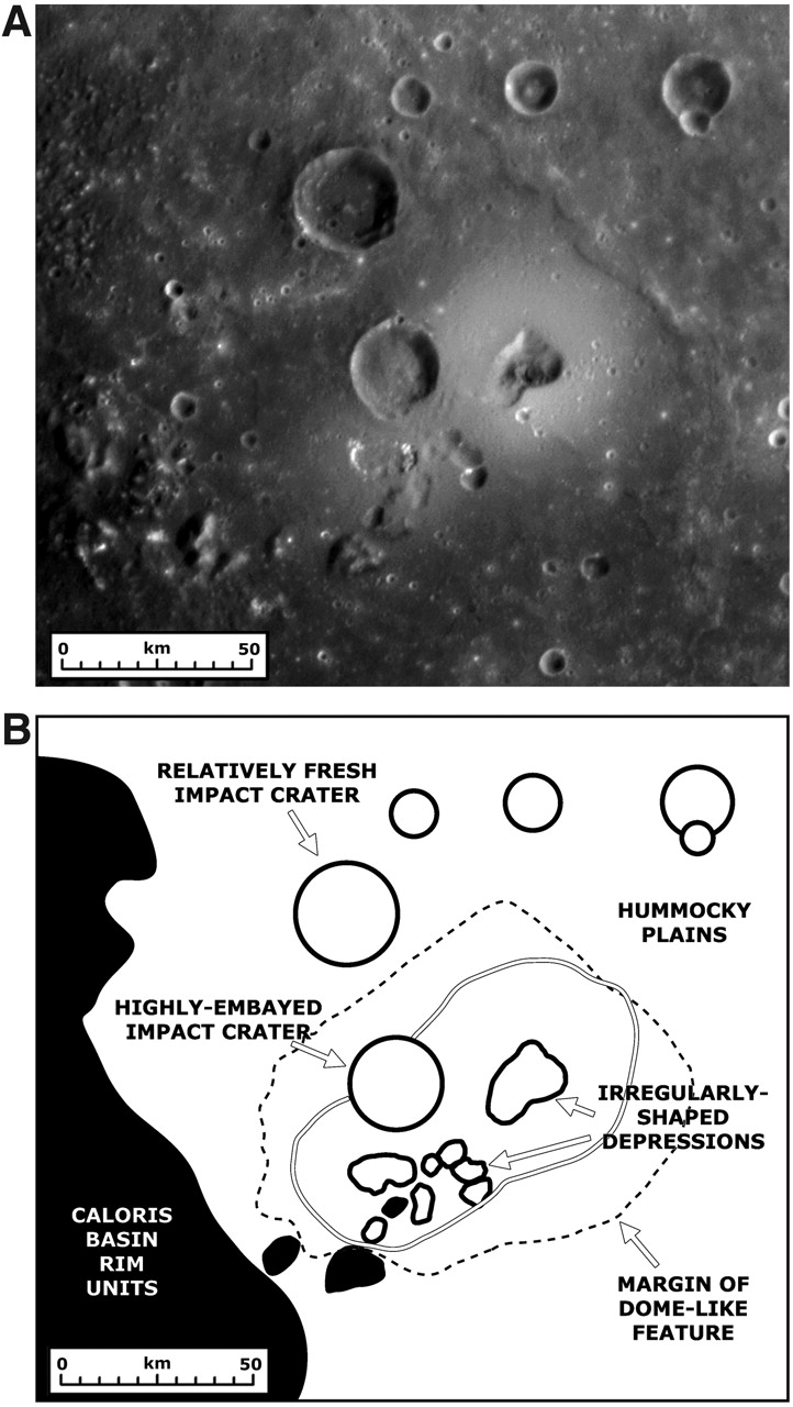
Of Interest: MESSENGER Science Team members are busy studying in detail the newly discovered volcanoes on Mercury. This figure, recently published in Science magazine, shows a NAC mosaic of the largest volcano currently identified on Mercury and a geologic sketch map of the major features in the surrounding area. The "irregularly-shaped depressions" are believed to correspond to volcanic vents, and the "margin of the dome-like feature" marks the outer limits of lava flows from the vents that are thought to have covered up the underlying surface of "hummocky plains." The unlabeled double line outlines bright material associated with the volcano, believed to be pyroclastic deposits ejected during volcanic eruptions at the vents. A "highly-embayed impact crater" also appears to have had lava flow up to its rim, while a slightly more distant impact crater is "relatively fresh" and unchanged by any lava. The volcano is located just inside the rim of the Caloris impact basin, labeled as "Caloris basin rim units" on this map. Maps such as this are aiding scientists as they work to understand the history of volcanism on Mercury.
Image Mission Elapsed Time (MET): Mosaic of 108826812 and 108826877
Instrument: Narrow Angle Camera (NAC) of the Mercury Dual Imaging System (MDIS)
Spacecraft Altitude: 10,500 kilometers (6,500 miles)
Of Interest: MESSENGER Science Team members are busy studying in detail the newly discovered volcanoes on Mercury. This figure, recently published in Science magazine, shows a NAC mosaic of the largest volcano currently identified on Mercury and a geologic sketch map of the major features in the surrounding area. The "irregularly-shaped depressions" are believed to correspond to volcanic vents, and the "margin of the dome-like feature" marks the outer limits of lava flows from the vents that are thought to have covered up the underlying surface of "hummocky plains." The unlabeled double line outlines bright material associated with the volcano, believed to be pyroclastic deposits ejected during volcanic eruptions at the vents. A "highly-embayed impact crater" also appears to have had lava flow up to its rim, while a slightly more distant impact crater is "relatively fresh" and unchanged by any lava. The volcano is located just inside the rim of the Caloris impact basin, labeled as "Caloris basin rim units" on this map. Maps such as this are aiding scientists as they work to understand the history of volcanism on Mercury.
Credit: Figure 1 from Head et al., Science, 321, 69-72, 2008.
For information regarding the use of MESSENGER images, see the image use policy.