 Click on image to enlarge. | Gazing into the Mariner 10 “Gore”Release Date: October 23, 2008 Topics: Comparisons with Mariner 10, Mercury Flyby 2, Velazquez |
Date Acquired: October 6, 2008
Image Mission Elapsed Time (MET): 131774286
Instrument: Narrow Angle Camera (NAC) of the Mercury Dual Imaging System (MDIS)
Resolution: 570 meters/pixel (0.35 miles/pixel) at the bottom of this image
Scale: The bottom of this image is about 580 kilometers (360 miles) across
Spacecraft Altitude: 22,400 kilometers (13,900 miles)
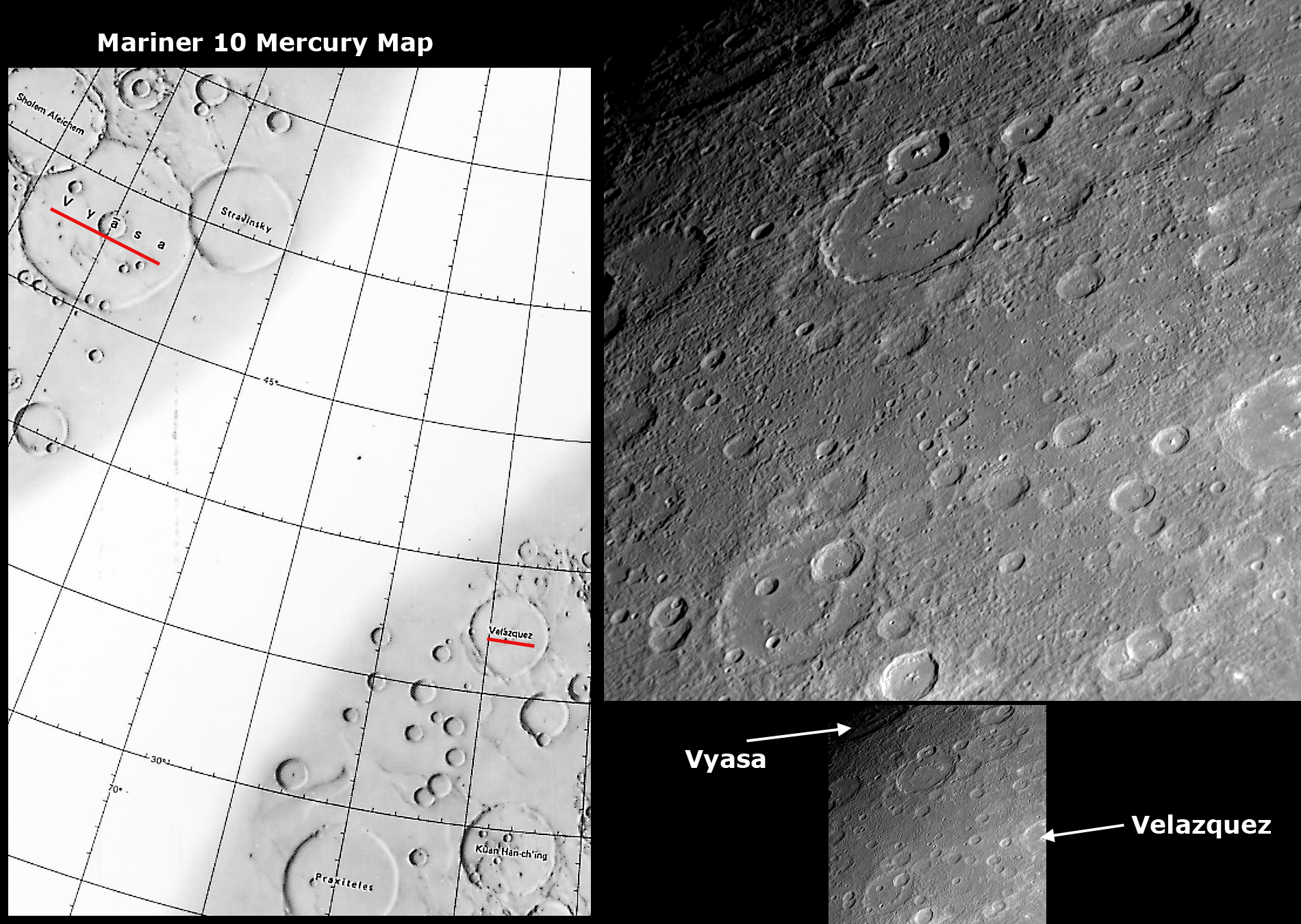
Of Interest: The Mariner 10 mission imaged about 45% of Mercury's surface, but a region in the northeastern portion of the side of the globe studied by that mid-1970s spacecraft had no imaging coverage, resulting in a distinctive “gore” on the Mariner 10 map of Mercury's surface. The left side of this figure shows a portion of the Mariner 10 map with the “gore.” MESSENGER's recent Mercury flyby provided the first spacecraft images of much of the surface within the Mariner 10 “gore,” and the specific NAC image on the right is located within the “gore.” Mariner 10 imaged the craters Vyasa (named for the ancient Indian poet) and Velazquez (named for the 17th century Spanish painter) but not the region between these two craters, the names of which are underlined in red on the left side Mariner 10 map. The upper center of the NAC image shows a newly seen large crater with a smooth floor and an incompletely developed or partially buried interior peak-ring structure.
Image Mission Elapsed Time (MET): 131774286
Instrument: Narrow Angle Camera (NAC) of the Mercury Dual Imaging System (MDIS)
Resolution: 570 meters/pixel (0.35 miles/pixel) at the bottom of this image
Scale: The bottom of this image is about 580 kilometers (360 miles) across
Spacecraft Altitude: 22,400 kilometers (13,900 miles)
Of Interest: The Mariner 10 mission imaged about 45% of Mercury's surface, but a region in the northeastern portion of the side of the globe studied by that mid-1970s spacecraft had no imaging coverage, resulting in a distinctive “gore” on the Mariner 10 map of Mercury's surface. The left side of this figure shows a portion of the Mariner 10 map with the “gore.” MESSENGER's recent Mercury flyby provided the first spacecraft images of much of the surface within the Mariner 10 “gore,” and the specific NAC image on the right is located within the “gore.” Mariner 10 imaged the craters Vyasa (named for the ancient Indian poet) and Velazquez (named for the 17th century Spanish painter) but not the region between these two craters, the names of which are underlined in red on the left side Mariner 10 map. The upper center of the NAC image shows a newly seen large crater with a smooth floor and an incompletely developed or partially buried interior peak-ring structure.
Credit: NASA/Johns Hopkins University Applied Physics Laboratory/Carnegie Institution of Washington
For information regarding the use of MESSENGER images, see the image use policy.