 Click on image to enlarge. | Mercury's Topography from the Second FlybyRelease Date: October 29, 2008 Topics: Mercury Flyby 1, Mercury Flyby 2, MLA, Mosaics, NASA Press Conference 10/29/2008 |
Date Acquired: January 14 and October 6, 2008
Instrument: Mercury Laser Altimeter (MLA), Narrow Angle Camera (NAC)
Scale: The MLA track shown is about 1,600 kilometers (1,000 miles) long
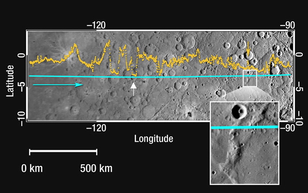
Of Interest: This figure shows about a 1,600 kilometer-long (1,000 mile-long) section of the MLA profile from MESSENGER's second Mercury flyby superimposed on a portion of the NAC approach mosaic from the mission's first Mercury encounter. The blue line indicates the spacecraft ground track, and the yellow dots show the altimetry data points; the blue arrow shows the spacecraft's direction of travel. This hemisphere has about 70% of the range in topography sampled by MLA during the first Mercury flyby and so this part of the equatorial hemisphere is smoother than that sampled last January. Near longitude -97° (263°E) there is a wrinkle ridge nearly 1 kilometer high (yellow arrow and white box containing a magnified view) that indicates horizontal shortening of the crust, possibly the result of global contraction associated with the cooling of the interior. In the longitude range of -115° to -120° (245°E to 240°E), the instrument sampled several craters of different depths with tilted floors (tilts of -0.5° to -0.2°; example indicated with a white arrow) that may have been the result of deformational processes.
Instrument: Mercury Laser Altimeter (MLA), Narrow Angle Camera (NAC)
Scale: The MLA track shown is about 1,600 kilometers (1,000 miles) long
Of Interest: This figure shows about a 1,600 kilometer-long (1,000 mile-long) section of the MLA profile from MESSENGER's second Mercury flyby superimposed on a portion of the NAC approach mosaic from the mission's first Mercury encounter. The blue line indicates the spacecraft ground track, and the yellow dots show the altimetry data points; the blue arrow shows the spacecraft's direction of travel. This hemisphere has about 70% of the range in topography sampled by MLA during the first Mercury flyby and so this part of the equatorial hemisphere is smoother than that sampled last January. Near longitude -97° (263°E) there is a wrinkle ridge nearly 1 kilometer high (yellow arrow and white box containing a magnified view) that indicates horizontal shortening of the crust, possibly the result of global contraction associated with the cooling of the interior. In the longitude range of -115° to -120° (245°E to 240°E), the instrument sampled several craters of different depths with tilted floors (tilts of -0.5° to -0.2°; example indicated with a white arrow) that may have been the result of deformational processes.
Credit: NASA/Goddard Space Flight Center/Johns Hopkins University Applied Physics Laboratory/Carnegie Institution of Washington
For information regarding the use of MESSENGER images, see the image use policy.