 Click on image to enlarge. | Ring Around the BasinRelease Date: May 19, 2011 |
Date acquired: May 13, 2011
Image Mission Elapsed Time (MET): 213808204
Image ID: 249397
Instrument: Wide Angle Camera (WAC) of the Mercury Dual Imaging System (MDIS)
WAC filter: 7 (748 nanometers)
Center Latitude: 33.36°
Center Longitude: 280.3° E
Resolution: 186 meters/pixel
Scale: This image is approximately 95 km (59 miles) across
Incidence Angle: 63.4°
Emission Angle: 11.4°
Phase Angle: 51.9°
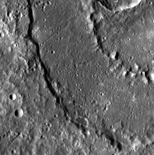
Of Interest: Mercury is covered with beautiful peak-ring basins, and a slice of one can be seen here. In fact, though this peak-ring basin was seen during MESSENGER's second flyby of Mercury, it does not yet have a name.
This image was acquired as part of MDIS's high-resolution surface morphology base map. The surface morphology base map will cover more than 90% of Mercury's surface with an average resolution of 250 meters/pixel (0.16 miles/pixel or 820 feet/pixel). Images acquired for the surface morphology base map typically have off-vertical Sun angles (i.e., high incidence angles) and visible shadows so as to reveal clearly the topographic form of geologic features.
The MESSENGER spacecraft is the first ever to orbit the planet Mercury, and the spacecraft's seven scientific instruments and radio science investigation are unraveling the history and evolution of the Solar System's innermost planet. Visit the Why Mercury? section of this website to learn more about the key science questions that the MESSENGER mission is addressing. During the one-year primary mission, MDIS is scheduled to acquire more than 75,000 images in support of MESSENGER's science goals.
Image Mission Elapsed Time (MET): 213808204
Image ID: 249397
Instrument: Wide Angle Camera (WAC) of the Mercury Dual Imaging System (MDIS)
WAC filter: 7 (748 nanometers)
Center Latitude: 33.36°
Center Longitude: 280.3° E
Resolution: 186 meters/pixel
Scale: This image is approximately 95 km (59 miles) across
Incidence Angle: 63.4°
Emission Angle: 11.4°
Phase Angle: 51.9°
Of Interest: Mercury is covered with beautiful peak-ring basins, and a slice of one can be seen here. In fact, though this peak-ring basin was seen during MESSENGER's second flyby of Mercury, it does not yet have a name.
This image was acquired as part of MDIS's high-resolution surface morphology base map. The surface morphology base map will cover more than 90% of Mercury's surface with an average resolution of 250 meters/pixel (0.16 miles/pixel or 820 feet/pixel). Images acquired for the surface morphology base map typically have off-vertical Sun angles (i.e., high incidence angles) and visible shadows so as to reveal clearly the topographic form of geologic features.
The MESSENGER spacecraft is the first ever to orbit the planet Mercury, and the spacecraft's seven scientific instruments and radio science investigation are unraveling the history and evolution of the Solar System's innermost planet. Visit the Why Mercury? section of this website to learn more about the key science questions that the MESSENGER mission is addressing. During the one-year primary mission, MDIS is scheduled to acquire more than 75,000 images in support of MESSENGER's science goals.
Credit: NASA/Johns Hopkins University Applied Physics Laboratory/Carnegie Institution of Washington
For information regarding the use of MESSENGER images, see the image use policy.