 Click on image to enlarge. | A Look at Craters Hosting Polar DepositsRelease Date: June 16, 2011 Topics: DEM/DTM, HD Resolution Images, MLA, Mosaics, NASA Press Conference 06/16/2011, Polar, Shadow and Water Ice |
Date Presented: June 16, 2011, at a NASA press conference
Instruments: Mercury Laser Altimeter (MLA) and Wide Angle Camera (WAC) of the Mercury Dual Imaging System (MDIS)
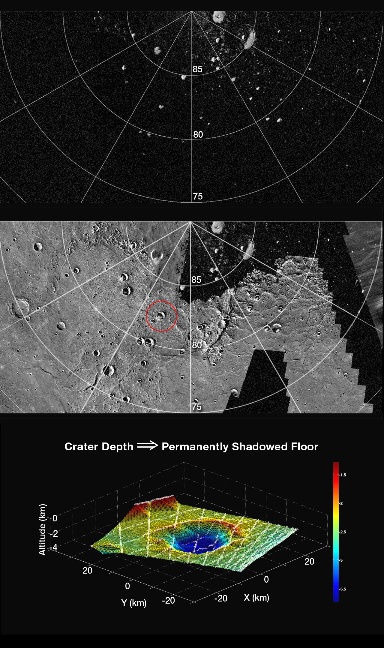
Of Interest: The top figure shows a portion of a radar image of Mercury's north polar region (latitudes indicated) obtained at the Arecibo Observatory. The bright features are polar deposits, areas of high radar backscatter, thought to consist of water ice and perhaps other ices preserved on the cold, permanently shadowed floors of high-latitude impact craters. (Credit: National Astronomy and Ionosphere Center, Arecibo Observatory)
The middle figure shows a portion of a northern hemisphere mosaic of Mercury's surface (500 m/pixel) on which the top radar image has been superposed. The prominent impact crater circled in red hosts an area of polar deposits and was profiled several times by MLA early in MESSENGER's science mapping phase. The crater is centered at 82.3°N, 342.8°E, and is 24 km in diameter.
The bottom figure shows a topographic contour map that was constructed from the several MLA profiles (lines of white circles) that pass through and near the crater circled in red. The color scale at right is in km, and north is at the 4 o'clock position. Calculations show that the topography of the crater is consistent with the prediction that the southernmost portion of the crater floor is in permanent shadow.
The MESSENGER spacecraft is the first ever to orbit the planet Mercury, and the spacecraft's seven scientific instruments and radio science investigation are unraveling the history and evolution of the Solar System's innermost planet. Visit the Why Mercury? section of this website to learn more about the key science questions that the MESSENGER mission is addressing.
Instruments: Mercury Laser Altimeter (MLA) and Wide Angle Camera (WAC) of the Mercury Dual Imaging System (MDIS)
Of Interest: The top figure shows a portion of a radar image of Mercury's north polar region (latitudes indicated) obtained at the Arecibo Observatory. The bright features are polar deposits, areas of high radar backscatter, thought to consist of water ice and perhaps other ices preserved on the cold, permanently shadowed floors of high-latitude impact craters. (Credit: National Astronomy and Ionosphere Center, Arecibo Observatory)
The middle figure shows a portion of a northern hemisphere mosaic of Mercury's surface (500 m/pixel) on which the top radar image has been superposed. The prominent impact crater circled in red hosts an area of polar deposits and was profiled several times by MLA early in MESSENGER's science mapping phase. The crater is centered at 82.3°N, 342.8°E, and is 24 km in diameter.
The bottom figure shows a topographic contour map that was constructed from the several MLA profiles (lines of white circles) that pass through and near the crater circled in red. The color scale at right is in km, and north is at the 4 o'clock position. Calculations show that the topography of the crater is consistent with the prediction that the southernmost portion of the crater floor is in permanent shadow.
The MESSENGER spacecraft is the first ever to orbit the planet Mercury, and the spacecraft's seven scientific instruments and radio science investigation are unraveling the history and evolution of the Solar System's innermost planet. Visit the Why Mercury? section of this website to learn more about the key science questions that the MESSENGER mission is addressing.
Credit: NASA/Johns Hopkins University Applied Physics Laboratory/Carnegie Institution of Washington
For information regarding the use of MESSENGER images, see the image use policy.